


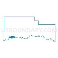
Precinct 22, Roosevelt County, Montana
About
Outline

Summary
| Unique Area Identifier | 612252 |
| Name | Precinct 22 |
| County | Roosevelt County |
| State | Montana |
| Area (square miles) | 18.87 |
| Land Area (square miles) | 18.12 |
| Water Area (square miles) | 0.75 |
| % of Land Area | 96.03 |
| % of Water Area | 3.97 |
| Latitude of the Internal Point | 48.10371260 |
| Longtitude of the Internal Point | -105.53337850 |
Maps


Graphs
Select a template below for downloading or customizing gragh for Precinct 22, Roosevelt County, Montana


Neighbors
Neighoring Voting District (by Name) Neighboring Voting District on the Map
- Precinct 18, Roosevelt County, MT
- Precinct 20, Roosevelt County, MT
- Precinct 24, Roosevelt County, MT
- Precinct 26, Roosevelt County, MT
- Precinct 27, Roosevelt County, MT
- Precinct 28, Roosevelt County, MT
Top 10 Neighboring County Subdivision (by Population) Neighboring County Subdivision on the Map
Top 10 Neighboring Place (by Population) Neighboring Place on the Map
Top 10 Neighboring Elementary School District (by Population) Neighboring Elementary School District on the Map
- Wolf Point Elementary School District, MT (4,205)
- Poplar Elementary School District, MT (3,523)
- Frontier Elementary School District, MT (430)
- Vida Elementary School District, MT (417)
Top 10 Neighboring Secondary School District (by Population) Neighboring Secondary School District on the Map
- Wolf Point High School District, MT (4,635)
- Poplar High School District, MT (3,523)
- Circle High School District, MT (1,734)
Top 10 Neighboring State Legislative District Lower Chamber (by Population) Neighboring State Legislative District Lower Chamber on the Map
- State House District 31, MT (9,191)
- State House District 30, MT (9,083)
- State House District 36, MT (8,070)
Top 10 Neighboring State Legislative District Upper Chamber (by Population) Neighboring State Legislative District Upper Chamber on the Map
- State Senate District 16, MT (18,529)
- State Senate District 15, MT (17,708)
- State Senate District 18, MT (17,057)
Top 10 Neighboring 111th Congressional District (by Population) Neighboring 111th Congressional District on the Map
Top 10 Neighboring Census Tract (by Population) Neighboring Census Tract on the Map
- Census Tract 9400.01, Roosevelt County, MT (4,549)
- Census Tract 9400.02, Roosevelt County, MT (4,298)
- Census Tract 9540, McCone County, MT (1,734)